
- "If we look at the soil structure, this area (Taman Melawati) is situated on limestone. From Hulu Klang to Batu Caves, this area has a long stretch of limestone, and when water flows through it for months, the risk of landslides increases."
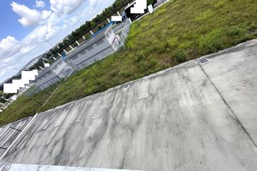
KUALA LUMPUR (Oct 16): The location of the landslide that occurred on Jalan E6, Taman Melawati, on Tuesday is one of 114 out of 600 hotspots identified in Selangor's Ampang Jaya district as red zones or highly at risk of landslides.
Selangor Menteri Besar Datuk Seri Amirudin Shari said that approximately 400 other areas are categorised as orange zones, which are at risk of landslides.
"If we look at the soil structure, this area (Taman Melawati) is situated on limestone.
"From Hulu Klang to Batu Caves, this area has a long stretch of limestone, and when water flows through it for months, the risk of landslides increases," he told a press conference after inspecting the landslide location on Jalan E6, Taman Melawati, on Wednesday.
The landslide incident around 10.15am on Tuesday, due to heavy rain, forced residents of 20 houses in Taman Melawati to evacuate their homes.
Four houses and one car were affected by the landslide, but no casualties were reported.
Amirudin, who is also the member of Parliament for Gombak, added that authorities had already identified areas prone to landslides and taken precautionary measures.
In another development, Amirudin also reminded residents, especially those in coastal areas of Selangor, to prepare for the high-tide phenomenon, which is expected to occur this Friday to Sunday.
Looking to buy a home? Sign up for EdgeProp START and get exclusive rewards and vouchers for ANY home purchase in Malaysia (primary or subsale)!

TOP PICKS BY EDGEPROP
The Cove @ Horizon Hills
Iskandar Puteri (Nusajaya), Johor


